
Datei:1943-10-01GerWW2BattlefrontAtlas.jpg

Größe dieser Vorschau: 616 × 600 Pixel. Weitere Auflösungen: 247 × 240 Pixel | 493 × 480 Pixel | 789 × 768 Pixel | 1.247 × 1.214 Pixel.
Originaldatei (1.247 × 1.214 Pixel, Dateigröße: 1,18 MB, MIME-Typ: image/jpeg)
| Diese Datei wird direkt von Wikimedia Commons aus eingebunden. Quellenangaben und Lizenzbedingungen befinden sich auf der unten zusätzlich eingeblendeten Commons-Beschreibungsseite. |
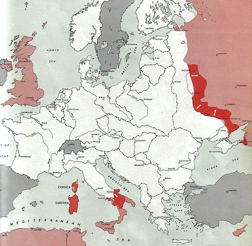
Atlas of the World Battle Fronts - War against Germany: 1943-10-01
← Previous map: 1943-09-15
→ Next map: 1943-10-15
Beschreibung
| Beschreibung |
  July 1, 1943 to June 30 1945 To the Secretary of War". (See Cover, Forward and Map details)  |
| Datum | |
| Quelle | Document "Atlas of the World Battle Fronts in Semimonthly Phases to August 15th 1945: Supplement to The Biennial report of the Chief of Staff of the United States Army July 1, 1943 to June 30 1945 To the Secretary of War" |
| Urheber | Army Map Service |
| Genehmigung (Weiternutzung dieser Datei) |
Public Domain: Work of US army |
Lizenz
Dieses Bild wurde von einem Mitglied der United States Army während der Ausführung seiner Dienstpflichten erstellt. Als eine Arbeit der Bundesregierung der Vereinigten Staaten ist dieses Bild in public domain.
|
 |
Dateiversionen
Klicke auf einen Zeitpunkt, um diese Version zu laden.
| Version vom | Vorschaubild | Maße | Benutzer | Kommentar | |
|---|---|---|---|---|---|
| aktuell | 18:56, 28. Aug. 2011 | | 1.247 × 1.214 (1,18 MB) | Cropbot | upload cropped version, operated by User:Finavon. Summary: caption cropped |
| 17:45, 24. Dez. 2007 |  | 1.274 × 1.754 (1,61 MB) | Mike Young | {{Information |Description= thumb|left|75pxthumb|right|75pxMap of the front against Germany: This map is taken from the source "Atlas of the World Battle Fronts in Semimonthly |
Dateiverwendung
Dieses Bild wird auf keiner Seite verwendet.
Globale Dateiverwendung
Die nachfolgenden anderen Wikis verwenden diese Datei:
- Verwendung auf da.wikipedia.org
- Verwendung auf en.wikipedia.org
- Verwendung auf en.wikisource.org
- Verwendung auf id.wikipedia.org
- Verwendung auf nl.wikipedia.org
- Verwendung auf no.wikipedia.org
- Verwendung auf uk.wikipedia.org
- Verwendung auf vi.wikipedia.org